 Introduction
On August 16, 1976, a devastating earthquake on the Cotabato Trench caused destruction on the island of Mindanao - the southernmost and largest of the Phillipine Islands.
The destructive tsunami that was generated in the Gulf of Moro and in the Celebes Sea killed about 8,000 people in coastal communities in North and South Zamboanga, North and South Lanao, North Cotabato, Maguindanao and Sultan Kudarat (Mindanao), and in the neighboring Sulu Islands.
This was the worst earthquake and tsunami disaster in the history of the Phillilines. Also, the Indonesian Hydrographic Office reported that unusual wave activity affected the islands of Sulawesi (Celebes Island) and Borneo.
Earthquake Origin Time, Magnitude, Epicenter, Focal Depth and Aftershocks
The earthquake occurred at 16:10 UTC of August 16, 1976 (local date August 17, 1976). The epicenter was in the Celebes Sea between the islands of Mindanao and Borneo. The Pacific Tsunami Warning Center's preliminary magnitude was given as 8.0 on the Richter scale and as 7.9 by other sources. There were many aftershocks following the main earthquake. A major aftershock on August 17 (local date) had a magnitude of 6.8. It was proceeded by at least fifteen smaller aftershocks.

Earthquake Intensities
The quake was widely felt throughout the region. PAGASA in the Phillipines gave the following Modified Mercalli Scale Intensities for Mindanao and the islands to the north.
Intensity VII - Cotabato City; Jolo-Sulu; Zamboanga City
Intensity VI - Basilan City; Pagadian City; Dipolog City; Malaybalay-Bukidnon
Intensity V - Cagayan de Oro City; Davao City; General Santos City
Intensity IV - Dumaguete City; Hinatuan Surigao del Sur; Tagbilaran-Bohol; Cebu City; Surigao-Surigao del Norte
Intensity II - Roxas City; Iloilo City; Tacloban City; Legaspi City; Palo-Leyte; Catbalogan-Samar
Summary of s field reports on main shock ground motions (source: PAGASA)
Tsunami Watch Issued
The Pacific Tsunami Warning Center (PTWC) in Honolulu issued a Tsunami Watch for the Pacific and queried tide gauge stations in Okinawa, Yap and Malakal. Based on negative reports from these stations, the watch was cancelled. Unfortunately, minutes after the earthquake, a large local tsunami struck the region. There was no time to issue a local warning.

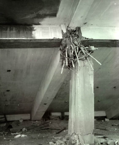
Death Toll and Damages
The earthquake occurred at night when offices and schools in Cotabato, Zamboanga and other cities were unoccupied - thus the loss of life was reduced. Although the quake had a large magnitude, surprisingly, it produced little ground deformation on land areas. However, there was extensive earthquake damage to buildings, bridges and roads in Mindanao and particularly at the city of Cotabato. The majority of buildings failed because of poor construction or inadequate foundations. A number of such buildings had been constructed on alluvial deposits with no adequate pile support. Evidence of ground liquefaction was found in many areas where mud bubbles had reached the surface.
About 8,000 people lost their lives. Ninety percent of all deaths were the result of the tsunami.


Tectonic Setting of the Region
The tectonics of the Celebes Sea-Sulu Sea region, between the Philippine Islands and the southern Philippine trench on the northeast and Borneo on the southwest, are complex. The region is characterized by deep basins and bold submarine ridges which have resulted from intensive, large-scale faulting of strike-slip, thrust, and block types accompanied by extensive volcanism (Krauss 1966). There are a total of 22 active volcanoes in the Phillipines.
Epicenters of the August 16, 1976 and of the March 6, 2002 earthquakes and proximity to the Cotabato Trench (Source:PHIVOCS)
There are several fault zones in the region that are capable of producing major earthquakes and destructive local tsunamis. The two major fault zones that are more dangerous are the Sulu Trench in the Sulu Sea and the Cotabato Trench. The Cotabato Trench is a region of subduction that crosses the Celebes Sea and the Moro Gulf in Southern Mindanao.
Deep-focus earthquakes occur along the NNE axis of the Celebes sea basin into the southern Philippines. Shallow-focus earthquakes occur between this axis and the southwestern side of the Philippine trench.

Seismicity of the Region
The Moro Gulf earthquake of August 16, 1976 occurred near the Cotabato trench - a region of subduction.
According to the PHIVOLCS historical catalog of earthquakes for the last 100 years, this region of the southern Phillipines is characterized by moderate to high seismicity. Most of the earthquakes that occur along the Cotabato trench are shallow, although very deep events also occur.
Distribution of earthquake hypocenters along a section of the Cotabato Trench subduction boundary (After B. Bautista 1996, PHIVOLCS)
The diagram by B. Bautista (1996) shows the concentration of earthquake hypocenters along a section of the tectonic boundary defined by the Cotabato Trench.
Recent Earthquakes in the Same Region
The March 6, 2002 Earthquake in Southern Mindanao - The most recent earthquake along the Cotabato Trench region of subduction occurred on March 6, 2002, at 05:15 am (local time). According to PHIVOLCS, the epicenter was at 6.1 N; 124.0 E, about 81 km SW of Isulan, Sultan Kudarat - in the same general area as that of August 16, 1976. Its focal depth was 15 km. According to Pacific Tsunami Warning Center (PTWC) the quake had a surface magnitude of 6.8. The U.S. Geological Survey assigned a moment magnitude (Mw) of 7.2 and a body wave magnitude (mB) of 6.3.
According to the Phillipine Office of Civil Defense (OCD), the earthquake caused several fatalities, numerous injuries and widespread damage in the provinces of Sultan Kudarat, Sarangani, North Cotabato and South Cotabato.
Source: http://www.drgeorgepc.com/Tsunami1976Phillipines.html
No comments:
Post a Comment